
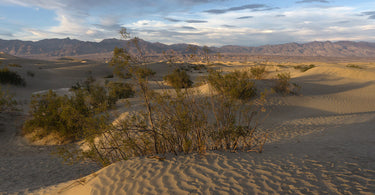
On July 10, 1913, a thermometer at Furnace Creek read 134°F, and that reading still stands as the hottest air temperature ever recorded on Earth. Death Valley holds a few other titles too: the lowest point in North America and the driest place on the continent. It sounds like a place to avoid. It is actually one of the most beautiful parks in the country.
Visit in the cooler months and you will find rippling sand dunes, a blinding white salt flat, hills streaked with pink and green, and snow on peaks above 11,000 feet. Death Valley is a park of extremes, and that is exactly why it belongs on your national parks bucket list, and why it feels so satisfying to finally pin it on your map.
Where is Death Valley National Park?
Death Valley stretches across eastern California and into Nevada, and at over 3.4 million acres there is a lot of ground to cover. The fastest route from Las Vegas runs through Pahrump, Nevada, and is about 120 miles, or roughly two hours. Paved entrances come in from Death Valley Junction, Beatty, Shoshone, Olancha and Lone Pine, Trona and US 95 in Nevada.
There is no public transportation to or within the park, so you will need a car. Gas is sold in the park at Furnace Creek, Stovepipe Wells and Panamint Springs. GPS directions in this remote country are notoriously unreliable, so carry a real road map as a backup.
President Herbert Hoover established Death Valley National Monument in 1933. The California Desert Protection Act of 1994 enlarged it and made it a national park.
A landscape shaped by faults, salt and sun
Death Valley is a long trough that formed between two big block faulted mountain ranges, the Amargosa Range to the east and the Panamint Range to the west. The contrast is stunning. Telescope Peak, the highest point in the park at 11,049 feet, rises only 15 miles from Badwater Basin, which sits 282 feet below sea level.
Badwater's salt flats cover nearly 200 square miles, among the largest protected salt flats in the world. Elsewhere you will find volcanic craters, polished canyons and the colorful hills of Artists Drive, which get their rainbow tones from volcanic deposits of different compositions. The park describes itself as an outdoor natural history museum, with fine examples of most of Earth's geological eras on display.
Life finds a way here too. Coyotes, ravens, roadrunners, ground squirrels and lizards are the animals you are most likely to see, and bighorn sheep roam the mountains. In spring, tiny Salt Creek pupfish dart through the shallow water at the Salt Creek boardwalk. After a wet winter, wildflowers can bloom in the low elevations in late March and early April.

Homeland of the Timbisha Shoshone
Long before it had its grim English name, this valley was home to the Timbisha Shoshone, who know it as Timbisha. Traditionally, families moved with the seasons, wintering on the valley floor and heading to the cooler mountains in summer, gathering at mesquite groves and springs along the way.
Their story in the park has not been easy. After decades of advocacy, much of it led by Timbisha women, the Timbisha Shoshone Homeland Act passed in 2000 and created the first tribal reservation within a national park. Today the park's entrance signs carry the words "Homeland of the Timbisha Shoshone."
The name Death Valley came later, from a group of lost pioneers who crossed it in the winter of 1849 to 1850. As far as historians know only one of them died here, but as the party climbed out over the Panamint Mountains, one man reportedly looked back and said "goodbye, Death Valley."
Best things to do at Death Valley National Park
Walk out onto Badwater Basin
Badwater is about 17 miles south of Furnace Creek on Badwater Road. An easy one mile out and back takes you to the edge of the salt flat, where the crust forms the polygon shapes Death Valley is famous for. In summer, enjoy the view from the parking area instead.
Drive Artists Drive to Artists Palette
The most popular scenic drive in the park is a nine mile, one way paved loop off Badwater Road through multicolored hills. Stop at Artists Palette, where the colors are most dramatic in afternoon light. Vehicles over 25 feet are not allowed because of the dips and sharp turns.
Hike Golden Canyon or climb the Mesquite Flat Sand Dunes
The Golden Canyon, Gower Gulch and Badlands Loop area offers routes from three to eight miles through a maze of golden badlands, with trailheads on Badwater Road and at Zabriskie Point. Near Stovepipe Wells, the Mesquite Flat Sand Dunes have no formal trail; the high dune is about one mile each way.
Watch sunrise at Zabriskie Point or Dantes View
Rangers recommend Dantes View, Zabriskie Point and the sand dunes for sunrise. For sunset, try Zabriskie Point, the dunes, Artists Palette or Aguereberry Point.
Stay up for the stars
Death Valley has no closing time, and it is certified at the highest Gold Tier level as an International Dark Sky Park. Rangers suggest Mesquite Flat Sand Dunes, Harmony Borax Works, Badwater Basin and Ubehebe Crater for stargazing. Ranger led night sky programs are offered in winter, so check the park calendar.

Tips for planning your visit
- Best time to go: November through March is the best hiking season. Summer temperatures can be dangerous at low elevations, so if you visit then, stay on paved roads, drink plenty of water and save hikes for the high mountains.
- Fees and reservations: No reservation is required to enter the park. Check the official NPS website for current fees and any reservation requirements before you go.
- Camping: The park has nine developed campgrounds. Furnace Creek Campground takes reservations on Recreation.gov for its October 15 to April 15 season; the others are first come, first served, and Sunset, the largest, almost always has room.
- Road conditions: Flash floods can close roads with little warning. Scotty's Castle is currently closed for flood recovery work, so check the park's alerts and road status page before you go.
- Be ready for remoteness: There is no cell service along most park roads, and help can be hours away. Carry extra water, food and a full tank.
- Road trip pairing: Pair Death Valley with Joshua Tree for a classic California desert road trip. Both became national parks under the same 1994 law.
🐝 A note from PennyBee
Here is our favorite Death Valley fact: it is the lowest spot in North America, but pinning it on your map will raise your spirits right up. Bring a big hat, a bigger water bottle, and a sense of wonder. The pupfish are small, but they have a lot of personality.
Add Death Valley to your national parks map
A park this extreme deserves a spot of honor. Our US National Parks Push Pin Map shows all 64 national parks and comes with a handmade wooden tree pin for each one, so you can mark Death Valley the day you get home and start dreaming about the next adventure.

For more ideas, read our guide on how to track the national parks you visit and browse our national and state park maps. Planning a desert loop? Our Joshua Tree National Park guide is the perfect companion to this one.
Featured image: Photo: Alexey Komarov, CC BY-SA 4.0, via Wikimedia Commons.
