
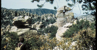
For the first time in six years, the United States has a brand new national park. On October 20, 2026, the Chiricahua National Park Act was signed into law, turning Chiricahua National Monument in southeastern Arizona into Chiricahua National Park. That makes it the 64th national park in the country and the first new one since New River Gorge in West Virginia earned the title in 2020.
If you are working toward visiting every national park, your bucket list just got one pin longer. Here is everything you need to know about Chiricahua, from how its strange rock forests formed to the best hikes for your first visit.
Where is Chiricahua National Park?
Chiricahua sits in the southeastern corner of Arizona, near the small town of Willcox in Cochise County. It is roughly a two hour drive east of Tucson, which makes it an easy addition to a Southern Arizona road trip that includes Saguaro National Park.
The park covers about 12,000 acres, which makes it one of the smaller national parks. Do not let the size fool you. What Chiricahua lacks in acreage it makes up for with some of the most unusual scenery in the Southwest.
A "Wonderland of Rocks"
The star of the show is the rock. Thousands of towering rhyolite spires, pinnacles and balanced boulders crowd the canyons, some of them perched so precariously you will wonder how they are still standing. The Chiricahua Apache called this place the "Land of Standing Up Rocks," and early visitors nicknamed it the "Wonderland of Rocks."

These formations were born from a massive volcanic eruption roughly 27 million years ago. Layers of ash settled and fused into rock, and millions of years of wind, water and ice carved that rock into the columns and hoodoos you see today.
A sky island full of life
Chiricahua rises from the Chiricahua Mountains, one of the "sky islands" of the Southwest. These are isolated mountain ranges that tower above the surrounding desert and grasslands, creating cool, forested habitats that feel worlds away from the valley floor below.

Because desert, grassland and forest ecosystems all meet here, the biodiversity is remarkable. Birders travel from around the country to spot species that are hard to find anywhere else in the United States. Keep your eyes open for white nosed coatis (a raccoon relative with a long striped tail), javelinas, deer and a huge variety of lizards and butterflies.
When the sun goes down, the show continues. Chiricahua is known for its dark skies, and on a clear night the Milky Way stretches across the sky above the spires.
Rich human history
Chiricahua is the homeland of the Chiricahua Apache, and the surrounding mountains hold thousands of years of human history. The land was first protected as a national monument in 1924, so it has been part of the National Park System for more than a century.
You can also step into pioneer life at Faraway Ranch, a historic homestead near the park entrance that tells the story of the early families who settled in Bonita Canyon and later ran a guest ranch here.
Best things to do at Chiricahua National Park
Drive Bonita Canyon Drive to Massai Point
The scenic drive winds about eight miles up through Bonita Canyon to Massai Point, where you will find sweeping views over the rock pinnacles and the valleys beyond. It is the perfect introduction to the park if you only have a few hours.
Hike the Echo Canyon Loop
At about 3.3 miles, the Echo Canyon Loop is the most popular hike in the park and for good reason. The trail weaves between towering spires, through narrow grottos and into shady forest. It is moderate, family friendly and endlessly photogenic.
Tackle the Heart of Rocks
For the full Chiricahua experience, take the longer trail out to the Heart of Rocks, home to some of the park's most famous formations, including Big Balanced Rock and Punch and Judy. Plan on most of a day, bring plenty of water and take your time.

Camp under the stars
Bonita Canyon Campground offers a small number of shaded sites tucked into the oaks and junipers. Reservations go quickly, so book ahead through Recreation.gov.
Tips for planning your visit
- Best time to go: Spring and fall bring mild temperatures and great hiking weather. Summer is warm with afternoon monsoon storms, and winter can bring occasional snow at higher elevations.
- Fees: Chiricahua has historically been free to enter. Check the official NPS website for the latest information before you go.
- Services: There are no restaurants or gas stations inside the park, and cell service is spotty. Fill your tank and pack snacks in Willcox.
- Beat the crowds: Chiricahua sees a tiny fraction of the visitors that Grand Canyon does, but parking at trailheads can still fill on spring weekends. Arrive early.
- Make it a road trip: Pair Chiricahua with Saguaro National Park near Tucson for a two park adventure in Southern Arizona.
🐝 A note from PennyBee
Here at PennyBee, a brand new national park is basically a holiday. If you visited Chiricahua back when it was still a national monument, we say it counts. Go ahead and give yourself the tree pin. We won't tell the rangers.
Add Chiricahua to your national parks map
Chasing all 64 national parks? Our US National Parks Push Pin Map shows every park, Chiricahua included, and comes with a handmade wooden tree pin for each one. Pin the parks you have already explored and save a tree for Chiricahua until you see those standing up rocks for yourself.

Looking for more park inspiration? Read our guide on how to track the national parks you visit, or browse our full collection of national and state parks maps.
Featured image: Photo: NPS, public domain, via Wikimedia Commons.

